-
Recent Searches
Recent Searches
- Travel Alerts
- My Account
- Customer Service
-
United Kingdom
 Checkout with PayPal
 Rated FEEFOERR:System.NullReferenceException: Object reference not set to an instance of an object.
at DirectFerries.WebTemplate.Core.Feefo.get_Results()
at DirectFerriesResp.Web.USPBar.GetFeefoRating()% by over FEEFOERR:System.NullReferenceException: Object reference not set to an instance of an object.
at DirectFerries.WebTemplate.Core.Feefo.get_Results()
at DirectFerriesResp.Web.USPBar.GetFeefoTotal() customers
Highly Rated
Rated FEEFOERR:System.NullReferenceException: Object reference not set to an instance of an object.
at DirectFerries.WebTemplate.Core.Feefo.get_Results()
at DirectFerriesResp.Web.USPBar.GetFeefoRating()% by over FEEFOERR:System.NullReferenceException: Object reference not set to an instance of an object.
at DirectFerries.WebTemplate.Core.Feefo.get_Results()
at DirectFerriesResp.Web.USPBar.GetFeefoTotal() customers
Highly Rated
 Our customers rate us FEEFOERR:System.NullReferenceException: Object reference not set to an instance of an object.
at DirectFerries.WebTemplate.Core.Feefo.get_Results()
at DirectFerriesResp.Web.USPBar.GetFeefoScore()/5 based on the independent review site
Our customers rate us FEEFOERR:System.NullReferenceException: Object reference not set to an instance of an object.
at DirectFerries.WebTemplate.Core.Feefo.get_Results()
at DirectFerriesResp.Web.USPBar.GetFeefoScore()/5 based on the independent review site
 Over 1 million prices checked daily
Great Deals
Over 1 million prices checked daily
Great Deals We're dedicated to saving you money. We check over 1 million prices every day to ensure to ensure we get you a great deal!
 Trusted by over 2.5 million customers
TrustedOur service is secure and easy to use, it's no wonder over 2,500,000 customers have put their trust in us
Trusted by over 2.5 million customers
TrustedOur service is secure and easy to use, it's no wonder over 2,500,000 customers have put their trust in us
Wallaroo to Lucky Bay Ferry
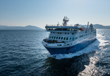
The Wallaroo Lucky Bay ferry route connects Australia with Australia. Currently there is just the 1 ferry company operating this ferry service, Sea Sa. The crossing operates up to 9 times each week with sailing durations from around 2 hours.
Wallaroo Lucky Bay sailing durations and frequency may vary from season to season so we’d advise doing a live check to get the most up to date information.
Wallaroo - Lucky Bay Ferry Operators
-

- 9 Sailings Weekly 2 hr
- Get price
Average Wallaroo Lucky Bay Prices
Prices shown represent the average one way price paid by our customers. The most common booking on the Wallaroo Lucky Bay route is a car and 2 passengers.
Wallaroo Guide
Wallaroo is a town and port located on the western side of the Yorke Peninsular in South Australia. The town lies on the foreshore and is 13 meters above sea level. The town's dry, Mediterranean, climate means its temperature is a few degrees higher than Adelaide's temperature. The temperature ranges are similar to those of Kadina and the weather patterns are similar to those of Kadina and Adelaide. The town is located around 160 km to the north west of Adelaide and is one of the Copper Triangle towns, famous for their copper mining industry and are collectively called "Little Cornwall". The town's name stems from the Aboriginal word 'Wadlu Waru' which means wallaby urine! The settlement of was established on Wallaroo Bay by 1861 and was declared a town in 1862. By 1865 the population was 3,000, and peaked at 5,000 in 1920. It was Yorke Peninsula's largest and most important port until 1923 when copper production ceased, and the largest and most important on Spencer Gulf until the Port Pirie smelters were established in 1890.
There is a daily ferry that operates between the harbour in Wallaroo and Lucky Bay, near Cowell on the Eyre Peninsula.
Lucky Bay Guide
Lucky Bay is located on the Eyre Peninsular in South Australia and was named by the explorer Matthew Flinders in 1802 when he took shelter in the bay. Flinders was exploring the region's coast when as he was sailing through the Recherce Archipelago his vessel HMS Investigator was hit by a summer storm. Whilst sheltered in the bay, botanist Robert Brown, discovered and named many new species of flora. Aside from sheltering from storms, the bay today is a popular destination to swim, snorkel, fish and to launch small boats.
The Eyre Peninsular is triangular in shape and has the Spencer Gulf to the east, the Great Australian Bight to the west and the Gawler Ranges to the north. The peninsular was named after Edward John Eyre who explored the region in the early/middle part of the 19th century although the area was first charted by Flinders and the French explorer Nicolas Baudin.
The port is a terminus for a passenger ferry which transports vehicles and passengers across the Spencer Gulf between Lucky Bay and Wallaroo.